Links and notes
Henrico County, Virginia : prepared under the direction of Lieut. Col. J.N. Nacomb, A.D.C., Chf. Topl. Engr. for the use of Maj. Gen. Geo. B. McClellan, commanding Army of Potomac | Library of Congress
https://www.loc.gov/resource/g3883h.cw0559200/
This is a 1862 map. I see here that the Phillips Mill is a saw mill, and probably a steam sawmill, thus the SS on another map.
--------------------------------------------------
A part of Henrico County | Library of Congress
https://www.loc.gov/resource/gvhs01.vhs00365/
Looks like the iron works were in a different location from the Revolutionary War West ham Foundry…..but not on our UR property….probably around the current strip mall!
------------------------------------------------------
Map of Henrico County, Virginia | Library of Congress
https://www.loc.gov/resource/g3883h.la002031/
-----------------------------------------------------------------
Map of Henrico County, Virginia | Library of Congress
https://www.loc.gov/resource/g3883h.la002082/
OK, this one shows exactly where the Old Folks Home of the True Reformers actually was. 1901.
-----------------------------------------------------------------------
Henrico County, Virginia | Library of Congress
https://www.loc.gov/resource/g3883h.cw0559300/
Look at the top half. Find Williams Island on the left edge. You will see our lake with B Green Sawmill under it. You will also see RD Phillips SS Mill.
--------------------------------------------------------------------------------
https://www.loc.gov/resource/glva01.lva00169/
Map of the vicinity of Richmond, Va. and part of the Peninsula
Contributor Names Campbell, Albert H. (Albert Henry), 1826-1899. Created / Published Richmond, Va. : E.C. Clarke, [1920?
-----------------------------------------------------------------
https://www.loc.gov/item/2011586686/
Title Map of Henrico County, Virginia : showing portions of Chesterfield County also City of Richmond Contributor Names T. Crawford Redd & Brother. Created / Published [Richmond, VA] : T. Crawford Redd & Bro., c1911.
---------------------------------------------------------------------------
https://www.loc.gov/item/lva0000005/
Title Richmond, Petersburg, and vicinity Genl. Grant's campaign war map Other Title Genl. Grant's camgaign war map Contributor Names Baumgarten, J. Bufford, John Henry, 1810-1870. Created / Published Boston, [Mass.] : J.H. Bufford, [1864]
---------------------------------------------------------------------------------
https://www.loc.gov/item/99439228/
Title Thirty five miles around Richmond, Va. Contributor Names Hotchkiss, Jedediah, 1828-1899. Bohn, Casimir. Created / Published Washington, D.C. ; Richmond, Va. : C. Bohn, 1867.
----------------------------------------------------------------------------
https://www.loc.gov/resource/g3701sm.gcw1036000/?sp=11&q=g3701sm.gcw1036000
Central Virginia image 11
Title [Civil War proof maps : United States]. Contributor Names Waters-Son (Firm) Created / Published [New York : Waters & Son, 1862-1864]
----------------------------------------------------------------------
https://www.loc.gov/item/gvhs01.vhs00369/
Title Map of the first & second division of the James River & Kanawha Canal. Contributor Names Confederate States of America. Army. Dept. of Northern Virginia. Chief Engineer's Office. Created / Published [S.l. : Chief Engineer's Office, D.N.V., 1863].
-------------------------------------------------------------------------
https://www.loc.gov/resource/glva01.lva00005/
Title Richmond, Petersburg, and vicinity Genl. Grant's campaign war map Other Title Genl. Grant's camgaign war map Contributor Names Baumgarten, J. Bufford, John Henry, 1810-1870. Created / Published Boston, [Mass.] : J.H. Bufford, [1864]
------------------------------------------------------------------------------------
https://www.loc.gov/item/2002627451/
Title [Map of Henrico County, Va. : showing fortifications around Richmond, north and east of the James River]. Created / Published [1864]
-----------------------------------------------------------------------

Westham Corporation
----------------------------------------------------------------------

----------------------------------------------------------------

--------------------------------------------------------------------
http://blog.richmond.edu/dsalisbury/files/2011/12/BodnerURhistoryPhotosstre…(appears to be a dead link)
--------------------------------------------------------------
http://blog.richmond.edu/dsalisbury/files/2011/12/Beverly12_5.pdf
-----------------------------------------------------------------------
http://digitool1.lva.lib.va.us:1801/view/action/nmets.do?DOCCHOICE=43225.xm…
---------------------------------------------------------------------------
https://www.loc.gov/resource/g3884r.cw0632800/
Richmond 1862-1865, pub. 1867 by Michie and Michler
includes mill and fortifications. Note: Westham Iron Works, Green's Mill directly on river, 2 spots on map listed as B. Green. One area listed B. Green has black squares on either side of dotted line, other B. Green is noted at intersection of three lines, with black squares (structures) positioned in T shape.
__________________________________________________________
https://www.loc.gov/resource/g3884r.cw1038000/
Region embraced in the operations of the armies against Richmond and Petersburg, Michie and Michler, pub. 1865, note Tibbs listed by normal location of sawmill. Tibbs may be found in Henrico Co. 1860 census, page 146. Listed as a carpenter. Of note: Green name noted three times in general area, including Green & Davis Quarry. Does anyone know if this Green is related or even Ben Green?
--------------------------------------------
http://memory.loc.gov/cgi-bin/map_item.pl
taken from Henrico County Historical Society. They have a number of maps on their website. http://henricohistoricalsociety.org/
-----------------------------------------------------
The Universal Magazine
Title/Description:
A New and Accurate Map of the Province of Virginia in North America
Publication Info:
[London: J. Hinton, 1779]. From The Universal Magazine, Vol 65, Dec1779. p. 281
Date:
1779
Scale:
1:1,480,000
http://cartweb.geography.ua.edu/lizardtech/iserv/calcrgn?cat=North%20Americ…
clearly see Westham on map
--------------------------------------
http://cartweb.geography.ua.edu/lizardtech/iserv/calcrgn?cat=North%20Americ…
Lloyd, J.T.
Title/Description:
Lloyd's Official Map of the State of Virginia
Publication Info:
New York: Wynkoop and Hallenbeck, 1862
Date:
1862
Scale:
1:630,000
-------------------------------
http://cartweb.geography.ua.edu/lizardtech/iserv/calcrgn?cat=North%20Americ…
Mitchell, Samuel Augustus
Title/Description:
County Map of Virginia and West Virginia
Publication Info:
Philadelphia: S.A. Mitchell, 1876
Date:
1876
Scale:
1:1,900,000
depicts Westhampton Granite and Westham
------------------------------------------------------
http://cartweb.geography.ua.edu/lizardtech/iserv/calcrgn?cat=North%20Americ…
Hardesty, H.H.
Title/Description:
Map of Virginia and West Virginia
Publication Info:
New York: H.H. Hardesty & Co., 1883; from Hardesty's Historical and Geographical Encyclopedia
Date:
1883
Scale:
1:1,521,000
-----------------------------------------------------------------
Henrico County, Virginia: prepared under the direction of Lieut. Col. J.N. Macomb, A.D.C., Chf. Topl. Engr. for the use of Maj. Gen. Geo. B. McClellan, commanding Army of Potomac, 1862
Date Issued: 1862
Place: Washington, D.C .Publisher: Corps of Topographical Engineers
Statement of responsibility: by E. Hergesheimer.Content: Scale approximately 1:75,000 (W 77°42ʹ46ʺ--W 77°10ʹ52ʺ/N 37°39ʹ36ʺ--N 37°14ʹ30ʺ)Content: Shows roads, railraods, drainage, houses, churches, mills, and woodlands.Content: Includes inset map of Richmond.Statement of responsibility: "Copy No. 1, for Maj. Gen. McClellan."Acquisition: Gift; Mrs. Daniel Butterfield; 1903-1904Funding: Mapping the Nation (NEH grant, 2015-2018)RLIN/OCLC: 66381383NYPL catalog ID (B-number): b20621831Other local Identifier: General Daniel Butterfield Collection 36Universal Unique Identifier (UUID): a2d7c250-dfb0-0132-4ed2-58d385a7b928
https://digitalcollections.nypl.org/items/30afeb60-dfb7-0132-87e4-58d385a7b…
buildings are noted but no land owners
_________________________________________________
Campagne en Virginie/ du Major Général M.isr de La Fayette,/ ou Se trouvent les Camps et Marches, ainsy que ceux/ du Lieutenant Général L.d Cornwallis./ par le Major Capitaine, aide de Camp du G.l La Fayette./ en 1781.
1781
Cartographer: Major Michel Capitaine du Chesnoy (1746-1804)
Origin: America, Virginia
OH: 35" x OW: 44"
India ink and watercolor on laid paper
Museum Purchase
Acc. No. 1930-686
http://emuseum.history.org/media/view/Objects/10017/214683?t:state:flow=aba…
http://emuseum.history.org/view/objects/asitem/classification@17/89/title-a…
Colonial Williamsburg's map----shows Westham----foundry was operating during this time period. Links don't appear to be live any longer. Check Library of Congress.
--------------------------------------------------------
https://digital.libraries.psu.edu/digital/collection/maps1/id/30127/rec/18
Title A map of the inhabited part of Virginia containing the whole Province of Maryland with part of Pensilvania, New Jersey and North Carolina Creator Fry, Joshua, approximately 1700-1754
ContributorJefferys, Thomas, -1771. ; Jefferson, Peter, 1708-1757.
ScaleScale 1:665,280. 1 in. = 10 1/2 miles
Note: Westham and Little Westham names are reversed today.
--------------------------------------------------------------------
https://digital.libraries.psu.edu/digital/collection/maps1/id/30072/rec/20
Title
Map of the region between Gettysburg, Pa. and Appomattox Court House, Va. exhibiting the connection between the campaign and battle-field maps
Creator
Michler, N. (Nathaniel), 1827-1881.
Contributor
Weyss, J. E. ; Thompson, Gilbert, 1839-1909. ; De la Camp, J. (John)United States. Army. Corps of Engineers. Scale approximately 1:290,000
Westham Iron Works noted
----------------------------------------------------
https://digital.libraries.psu.edu/digital/collection/maps1/id/29945/rec/25
Title
A general map of the middle British colonies in America : viz. Virginia, Maryland, Delaware, Pensilvania, New-Jersey, New-York, Connecticut and Rhode-Island : of Aquanishuonigy the country of the confederate Indians comprehending Aquanishuonigy proper, their places of residence, Ohio and Thuchsochruntie their deer hunting countries, Couchsachrage and Skaniadarade their beaver hunting countries, of the Lakes Erie, Ontario and Champlain, and of part of New-France : where is also shewn the antient and present seats of the Indian nationsAlternative TitleMiddle British colonies in America
CreatorEvans, Lewis, 1700?-1756
Contributor
Dodsley, Robert, 1704-1764 ; Turner, James, -1759.Pennsylvania. Secretary of the Commonwealth.
Scale approximately 1:2,250,000
------------------------------------------------------------
http://digitool1.lva.lib.va.us:1801/view/action/nmets.do?DOCCHOICE=43211.xm…
http://digitool1.lva.lib.va.us:1801/view/action/nmets.do?DOCCHOICE=43225.xm…
by John Wood 1819 Henrico Co. VA
CHECK LINK
______________________________
https://www.loc.gov/item/2005625010/
TitlePosition of Richmond, Va.Contributor NamesAbbot, Henry L.McClellan, George B. (George Brinton), 1826-188Notes
- Shows positions of Federal and Confederate armies in June and July 1862 in Richmond region.- Relief shown by hachures.- Pen-and-ink and watercolor on irregularly shaped piece of tracing linen, sectioned in 2 and mounted on cloth.- "Copied from a map captured from the enemy June 27th 1862."- LC Civil War maps (2nd ed.), H97- Imperfect: Discoloration along right edge and along fold lines.- Available also through the Library of Congress web site as raster image.Medium1 ms. map : col., cloth ; 76 x 69 cm.Call Number/Physical LocationG3884.R5S5 1862 .A4Repository
Library of Congress Geography and Map Division Washington, D.C. 20540-4650 dcu5.Humphreys, A. A. (Andrew Atkinson), 1810-1883.
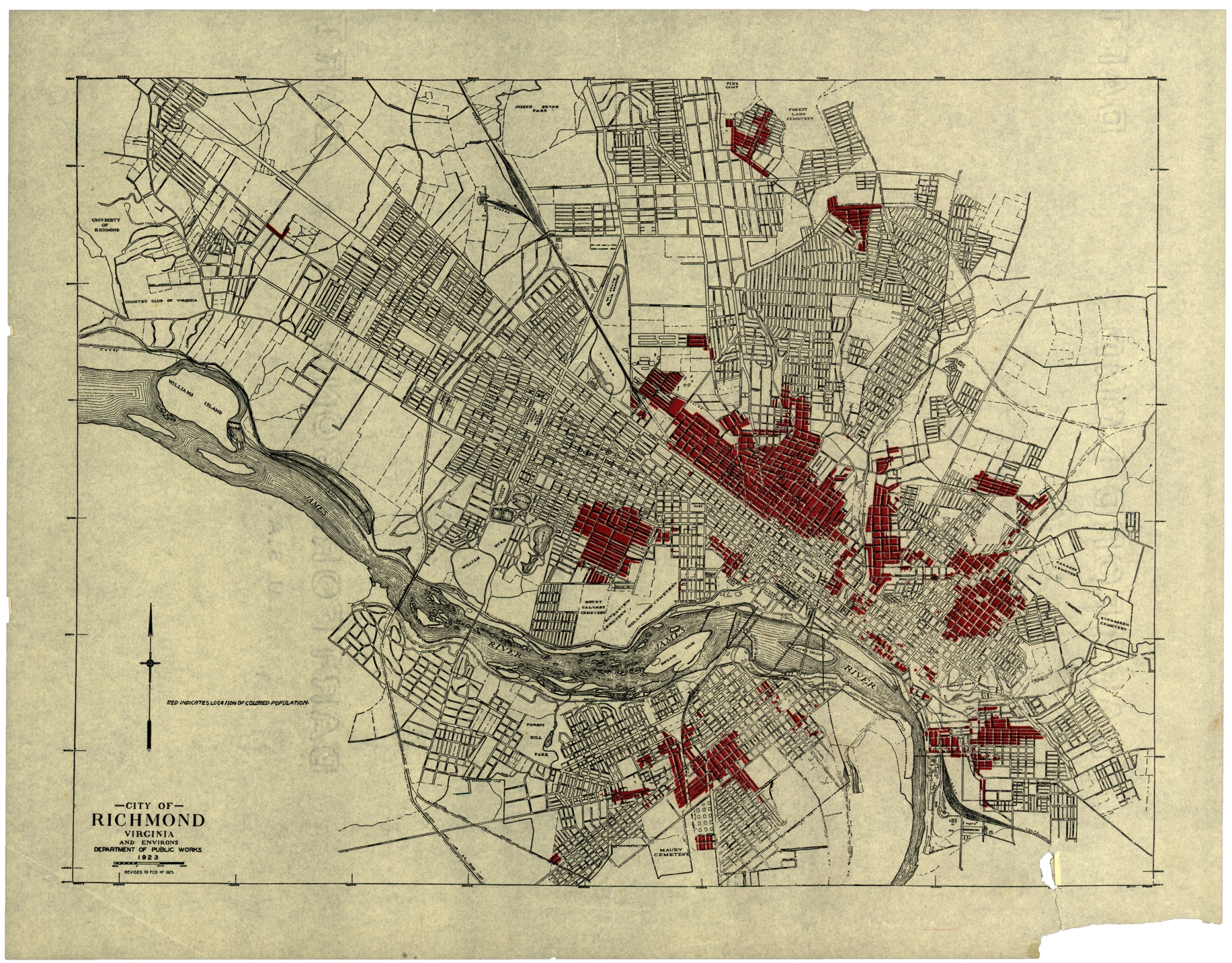
City of Richmond Virginia and Environs, Department of Public Works, 1923
Library of VA
http://www.virginiamemory.com/online-exhibitions/items/show/11
City of Richmond Virginia, Harland Bartholomew & Associates,
Transit Routes Direct to Downtown District, 1946

Wagner's Complete Map of Richmond, A.C. Wagner Co., 1927
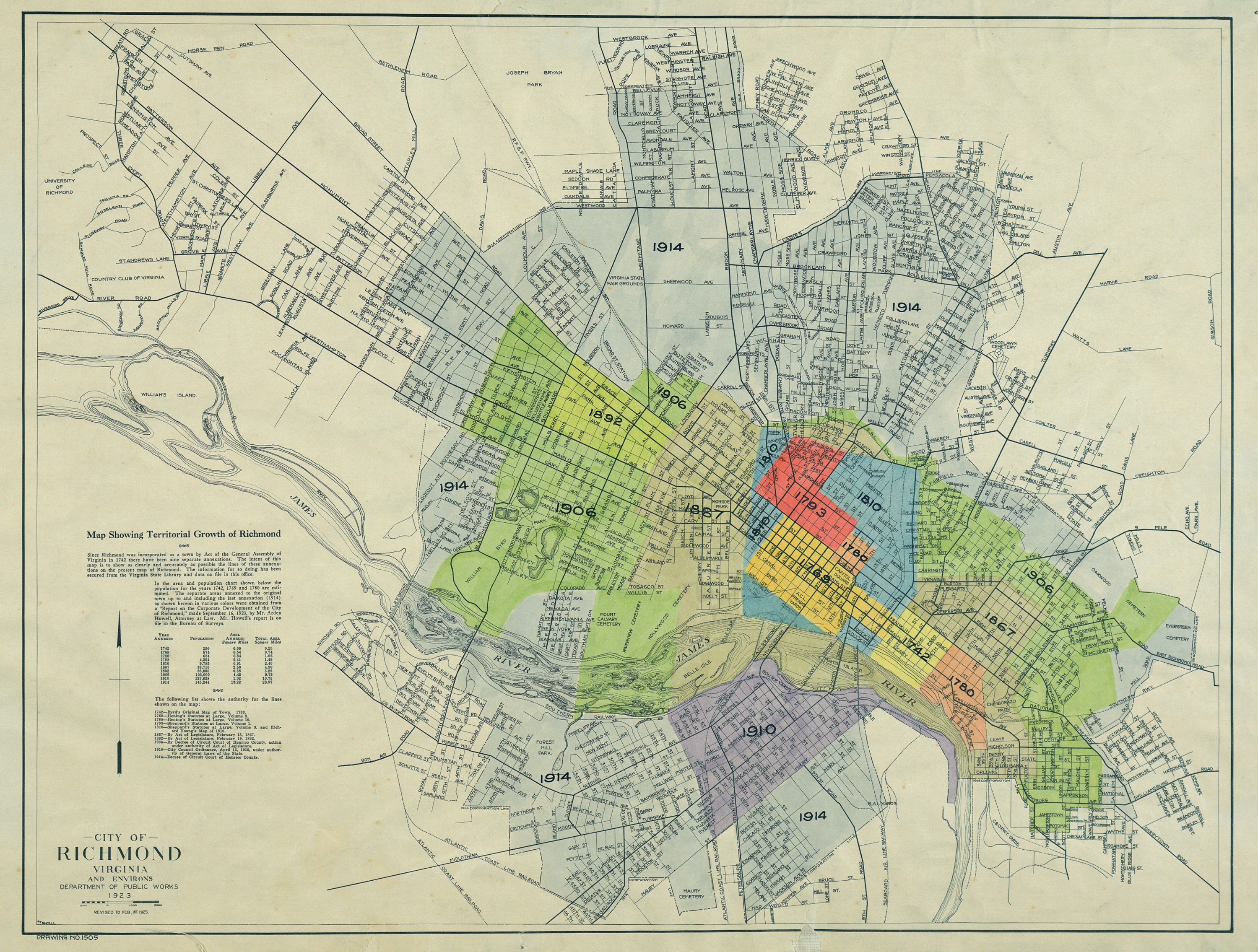
City of Richmond, Virginia and Environs, Department of Public Works, 1923
https://collegian.richmond.edu/?a=d&d=COL19941006.2.51&srpos=12&…------
steam tunnel map and article - Collegian 6 Oct 1994
https://www.loc.gov/resource/g3884wm.g3884wm_g090911921/?sp=7&r=0.425,0…
Image 7 of Sanborn Fire Insurance Map from Westhampton, Henrico County, Virginia. Sanborn Map Company, Jul 1921, Library of Congress
Westham Plantation House - Westham Plantation House DHR ID 043-0222
VA Department of Historic Resources
https://www.dhr.virginia.gov/wp-content/uploads/2020/05/043-0222_Westham_Pl…